Comunicado de imprensa
UNESCO escolhe oito novas áreas para a Rede Mundial de Geoparques: duas estão no Brasil

A Organização das Nações Unidas para a Educação, a Ciência e a Cultura (UNESCO) aprovou hoje (13/04), durante a 214ª sessão do seu Conselho Executivo realizada em Paris, França, a inclusão de oito novos Geoparques Globais. Na lista divulgada, dois estão no Brasil: o Geoparque Caminhos dos Cânions do Sul, situado entre os estados de Santa Catarina e Rio Grande do Sul; e o Geoparque Seridó, localizado no estado do Rio Grande do Norte. Com as novas inclusões, a Rede Mundial de Geoparques reúne agora 177 áreas em 46 países.
A Rede Mundial de Geoparques da UNESCO reconhece patrimônios geológicos que apresentam extraordinária relevância em diversidade biológica e cultural para o mundo. Além disso, os geoparques atendem as comunidades locais, combinando a conservação de seu patrimônio geológico único com o acesso público e o desenvolvimento sustentável. A cada dois anos, o Conselho Executivo da UNESCO se reúne em assembleia para a escolha de novas áreas.
Neste ano, além dos geoparques situados no Brasil, também foram incluídos na Rede:
Platåbergens (Suécia), Kefalonia-Ithaca (Grécia), Ries (Alemanha), Salpausselkä (Finlândia), Mëllerdal (Luxemburgo) e Buzău Land (Romênia).
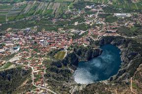
Geoparque Seridó, Brasil
Localizado no estado do Rio Grande do Norte, o sítio está inserido em um bioma rico em biodiversidade e abrange uma área de 2.800 km² no semiárido nordestino. Abriga mais de 120 mil habitantes, incluindo comunidades como os quilombolas, que mantêm viva a memória de seus ancestrais escravizados da África para preservar sua cultura por meio de práticas tradicionais, museus e centros culturais. O geoparque é um testemunho dos últimos 600 milhões de anos da história da Terra e abriga uma das maiores mineralizações de scheelita da América do Sul, um importante minério de tungstênio, além de fluxos de basalto decorrentes da atividade vulcânica durante as Eras Mesozoica e Cenozoica. Essa geodiversidade determina em grande parte a biodiversidade única da região, caracterizada especialmente pela caatinga (“floresta branca”, na língua tupi), uma ecorregião marcada por flora subtropical específica. A caatinga é o único bioma exclusivamente brasileiro, o que significa que grande parte de seu patrimônio biológico não pode ser encontrado em nenhum outro lugar do planeta.


Geoparque Caminhos dos Cânions do Sul, Brasil
Situado entre os estados de Santa Catarina e Rio Grande do Sul, abrange uma área de 2.830,8 km² e abriga 74.120 habitantes. É caracterizada pela Mata Atlântica, um dos ecossistemas mais ricos do planeta em termos de biodiversidade. Os habitantes pré-colombianos da área costumavam se abrigar em paleotocas (cavidades subterrâneas escavadas pela extinta megafauna paleovertebrada, como a preguiça gigante), cujos numerosos vestígios ainda são visíveis no geoparque. Além disso, o local apresenta os cânions mais impressionantes da América do Sul, formados pelos processos geomorfológicos únicos que o continente sofreu durante a dissolução do supercontinente Gondwana, há cerca de 180 milhões de anos.


Salpausselkä UNESCO Global Geopark, Finland
Home to around 177,000 inhabitants, the Salpausselkä UNESCO Global Geopark is located in southern Finland, in the southernmost part of the Finnish Lakeland, covering an area of 4,506 km². Around 21% of the geopark is covered by water and over half by forests. The hundreds of lakes in the geopark are a central feature of the landscape, along with the long, distinct Salpausselkä ridges. Extending over more than 600 km across southern Finland, the ridges consist of sediments deposited by glaciers. They bear witness to climate change, specifically to the the Younger Dryas, the cool period that lasted roughly from 12,900 to 11,600 years ago, and disrupted the Northern Hemisphere’s warming trend at the end of the Pleistocene Epoch (2.6 million to 11,700 years ago). Studied since the 19th century, these ridges constitute Finland’s best-known geological heritage set in a landscape formed by melting glaciers that created glaciofluvial landforms and rock formations that store an abundance of groundwater and provide the region with naturally high-quality drinking water.


Ries UNESCO Global Geopark, Germany
Most of the Ries UNESCO Global Geopark area lies in the state of Bavaria, with a smaller part in the state of Baden-Würtemberg comprising the Ries Crater, situated between the Swabian and Franconian Alb in southern Germany. The geopark covers an area of 1,749 km2 with around 162,500 inhabitants. Some 15 million years ago, a meteorite collided with Earth in this very place, leaving an impact crater that is the best-preserved meteorite crater in Europe and the most intensively studied impact structure among the nearly 200 known craters worldwide. Visitors can explore the Nördlinger Ries impact crater and learn about its geology and history by following nature trails which take hikers to scenic outlooks, on their own or on guided tours. Information centres and school programmes are also available. The geopark provides an intriguing insight into the Earth’s history through its unique natural landscape, cultural and culinary history.


Kefalonia-Ithaca UNESCO Global Geopark, Greece
In Western Greece, the Kefalonia – Ithaca UNESCO Global Geopark is an island complex belonging to the Heptanese (from the Greek for seven, the number of principal Ionic islands). Kefalonia occupies an area of 773 km² and is home to 35,801 inhabitants and Ithaca’s 117 km² are inhabited by3,084 people. The geopark is rich in geosites of karstic origin such as caves, sinkholes and underground streams, all of which are scattered throughout the islands telling of a geological history that goes back more than 250 million years. Both islands are located very close to a mountain chain shaped like an arc (the Hellenic arc) formed by the subduction of the African Plate under the Eurasian Plate. It is the most tectonically active region in Europe. The geopark also has a literary significance as Kefalos and Ithaca are named in the Odyssey as the homeland of Ulysses, the hero of Homer’s epic poem. The geopark is also home to prehistoric Hellenistic and Roman monuments, medieval castles, Byzantine and post-Byzantine monasteries, traditional settlements, windmills, bridges and lighthouses, a rich cultural heritage scattered over the area’s extraordinary geological features.


Mëllerdall UNESCO Global Geopark, Luxembourg
In Eastern Luxembourg, the rural Mëllerdall UNESCO Global Geopark covers 256 km² with a population of about 25,500 inhabitants. The geopark is situated in the centre of the Trier-Luxembourg Basin, which extends from the Paris Basin to the Rhenish Massif. It features the Luxembourg Sandstone Formation which reaches a thickness of up to 100 metres and dates from the Lower Liassic age (205 to 180 million years ago). It forms one of the most spectacular sandstone landscapes in Western Europe and has been a tourist attraction since the late 19th century. Today, the region can be explored by following a dense network of well-signposted hiking trails, including the 112 km-long Mullerthal Trail, which has won the Leading Quality Trails – Best of Europe award.


Buzău Land UNESCO Global Geopark, Romania
In the Carpathian Bend Area in Romania, the hilly and mountainous territory of the Buzău Land UNESCO Global Geopark covers 1,036 km² and is home to some 45,000 inhabitants. Several tectonic plates collided in the region, creating a very complex fold and thrust mountain range which was later eroded by glacial action. One of the most geodynamically active areas in Europe, the geopark exhibits 40 million years of geological history. Over this period, it ectonic movements pushed up mountains and transformed a deep-sea environment into a terrestrial one. Fossils of marine species, terrestrial vegetation, mammals and birds dating from the last glaciation have been well-preserved in the Carpathians. Many fossils of beetles, spiders, crustaceans, reptiles and other species are conserved in amber, a fossilized resin. Some of the longest and deepest salt caves in the world are also found here, remnants of large deposits of salt and gypsum formed by the evaporation of shallow enclosed bodies of water. This rich geodiversity has influenced a unique cultural heritage with local legends in which mud volcanoes become dragons, mud boilers are traps made by giants to catch cattle, and the future can be predicted by looking through a lens of amber.


Platåbergens UNESCO Global Geopark, Sweden
In West Sweden, the Platåbergens UNESCO Global Geopark covers an area of 3,690 km2 and is home to 289,198 inhabitants. It presents a unique landscape of 15 flat-topped Table Mountains, platåbergen in Swedish, after which the site is named. These mountains were shaped by erosion during the last Ice Age 115,000 years ago. The area also covers the Västgöta Plain with its shallow floodplain lakes, undulating ridges and well-preserved cultural landscapes. Some of Sweden’s most interesting historical discoveries have been made in this area where museums preserve numerous vestiges that bear witness to inhabitants’ use of the local stone over the millennia: from megalithic graves (5,300-4,700 BCE) to the first known stone church in Sweden, built by Christian Vikings in the early 11th century.


Contatos para imprensa
Clare O'Hagan
UNESCO Press Officer
c.o-hagan@unesco.org
Photos and B-rolls for media: